
 Jaidad
Faisal Town Phase 2 in numbers: 75,168 plots, block by block
Faisal Town Phase 2 on Jaidad Finder's free map: 75,168 plots, the commonest sizes, parks, mosques and schools, and the plots for sale, all from our own map.
Faisal Town Phase 2, Islamabad: 75,168 plots on Jaidad Finder's free map. Each plot is drawn from the society's own plan and can be found by block and number.
38 plots with a live sale listing
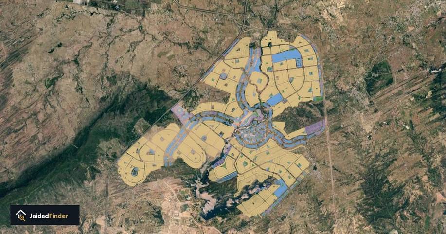
Open the Faisal Town Phase 2 map
The plots
- Residential: 68,735
- Commercial: 6,129
- Blocks and sectors: 81
- Streets on the map: 171
The commonest plot sizes

Residential plots, by the size printed on the plan (feet, width x depth):
- 25 x 50: 27,230 plots (1,250 square feet, sold as 5 marla)
- 30 x 60: 12,993 plots (1,800 square feet, sold as 8 marla)
- 35 x 70: 8,379 plots (2,450 square feet, sold as 10 marla)
- 50 x 90: 4,496 plots (4,500 square feet, sold as 1 kanal)
- 40 x 80: 3,512 plots (3,200 square feet)
Parks, mosques and schools

The plan sets aside these sites. They are marked on the map:
- Parks: 71
- Mosques: 39
- Schools and colleges: 31
- Health: 4
Plots for sale

38 plots in Faisal Town Phase 2 have a live listing on Jaidad Finder. Each one is placed on its own plot on the map. See the plots for sale in Faisal Town Phase 2.
See it on the map
Open the Faisal Town Phase 2 map and type a block and plot number to find any plot. About Faisal Town Phase 2: where it is, its blocks and its approval record.
Before you pay for a plot
These checks are free and take a few minutes:
- Find the plot. Open the Faisal Town Phase 2 map and type the block and plot number. The map is drawn from the society's own plan. You can see where the plot sits, its size and its street.
- Check the society. CDA and RDA publish lists of approved, cancelled and illegal housing schemes. Check any scheme against the CDA and RDA lists.
- Check the plot is inside the approved area. An approval can cover only part of a society's land. On the map, a plot inside an approved area shows a green tick. A plot near the edge of that area could fall on either side of the line.
- Look at the ground. The map shows the same land in dated satellite photographs. You can see what has been built and when.
- Ask the authority. Always check with CDA or RDA before you pay. Keep a copy of what they tell you.
What the words mean
- NOC: CDA's no objection certificate for development. CDA says sponsors start development and the sale of plots once the NOC is issued.
- Layout plan (LOP): "LOP: Approved" on CDA's list means CDA has approved the scheme's layout plan.
- RDA approved: on RDA's list of approved housing societies. RDA's own words say what was approved and how much land it covers.
- Cancelled: the authority cancelled the layout plan or the NOC.
- Illegal: on an authority's list of illegal schemes, or named illegal in a CDA public notice.
- Approved area: the land the authority's record covers. A society's map can hold more land than its approval. This is why our map marks the approved area plot by plot.
Figures from Jaidad Finder's map on 10 November 2026. Every count is of the plots on the published map.